
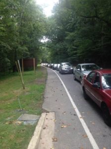
Raise your hand if this has happened to you: A beautiful Saturday or Sunday dawns, and you pack your family into the car for an adventure in the C&O Canal National Historical Park. When you arrive at Great Falls to park, the line of cars to get in is a mile long!
To help cure your parking blues, we have compiled a list of other parking options available near the C&O Canal National Historical Park in Montgomery County. Take this opportunity to explore a new and interesting part of the Park!
Click on each link to see a map and get directions. Mile markers refer to towpath miles.
You can download parking locations for the entire C&O Canal National Historical Park here.
Downstream (east) of Great Falls. (All parking lots on Clara Barton Parkway are accessible from lanes leading inbound for DC.):
Lock 5 Parking: Mile Marker 5
Small lot off of Clara Barton Parkway, near Lock 5 and the Brookmont Bridge.
Lock 6 Parking: Mile Marker 5.4
Small lot off of Clara Barton Parkway, near Lock 6 and Lockhouse 6.
Sycamore Island Parking: Mile Marker 6.4
Small lot along Clara Barton Parkway near the access to Sycamore Island.
Lock 7 Parking: Mile Marker 7
Small lot off Clara Barton Parkway, near Lock 7 and Lockhouse 7.
Lock 8 Parking: Mile Marker 8.4
Small lot off Clara Barton Parkway, near Lock 8 and Lockhouse 8.
Lock 10 Parking: Mile Marker 8.8
Small lot off Clara Barton Parkway, near Lock 10 and Lockhouse 10.
Carderock South Parking Lot: Mile Marker 10.4
Large lot. Follow signs off Clara Barton Parkway to Carderock parking. Near Billy Goat Trail C and Carderock climbing area.
Carderock North Parking: Mile Marker 10.9
Large lot. Follow signs off Clara Barton Parkway to Carderock parking. Near Billy Goat Trail C and Carderock climbing area.
Anglers Parking: Mile Marker 12.4
Small lot off MacArthur Boulevard, across the street from Old Anglers Inn and near Billy Goat Trails A & B.
Upstream (west) of Great Falls
Swains Parking: Mile Marker 16.7
Small lot. Turn off River Road onto Swains Lock Rd. Near Swains Lockhouse 21, Lock 21, and Swains campsite.
Lock 22 Parking – Pennyfield: Mile Marker 19.7
Small lot. Turn off River Road onto Pennyfield Lock Rd. Near Lockhouse 22 and Lock 22.
Lock 23 Parking – Violettes Lock: Mile Marker 22.1
Small lot. Turn off River Road onto Violettes Lock Rd. Near Violettes Lock 23.
Rileys/Seneca Parking: Mile Marker 22.7
Large lot. Turn off River Road onto Rileys Lock Rd. Near Rileys Lock 24 and Seneca Aqueduct and Creek.
Sycamore Landing Parking: Mile Marker 27
Small lot. Turn off River Road on Sycamore Landing Rd. Near Sycamore Landing Boat Ramp.
Edwards Ferry Parking: Mile Marker 30.9
Small Lot. Take Edwards Ferry Rd. Near Lockhouse 25 and Lock 25.
Whites Ferry Parking: Mile Marker 35.5
Large lot. Off Whites Ferry Rd, near Whites Ferry, with service across the Potomac to Virginia.
Dickerson Conservation Park Parking: Mile Marker 39.5
Small lot off Martinsburg Rd. near Dickerson Conservation Park.
Monocacy Aqueduct Parking: Mile Marker 42.2
Small lot of Mouth of Monocacy Rd. near Monocacy Aqueduct.