
Montgomery County
1.07 Alexandria Aqueduct
Location: Aqueduct Bridge, Washington, DC 20007 Mile 1.07
About: Built between 1833 and 1843, the Alexandria Aqueduct Bridge stood as a technological marvel of early 19th century engineering. It was designed to connect the Chesapeake and Ohio Canal to the neighboring seaport at Alexandria via a seven-mile-long canal.
Tasks:
-Pick up and remove trash
-Survey site for hazards and note condition of the site.
5.03 Lock 5 area
Location: Mile Marker 5
Lock 5, Bethesda, MD 20816
About: The stone is original and came from Aquia creeks and a nearby quarry.
Tasks:
-Pick up and remove trash from site.
-Paint park features such as signs and picnic tables.
-Survey site for hazards and note condition of the site.
-Clean signs.
5.5 Lock 6 area
Location: 6100 Clara Barton Parkway Bethesda, MD 20816 Mile 5.4
Tasks:
-Pick up and remove trash from site.
-Paint park features such as signs and picnic tables.
-Survey site for hazards and note condition of the site.
-Clean signs.
7.04 Lock 7 area
Location: 38.9642839, -77.1381624 Mile Marker 7
Tasks:
-Pick up and remove trash from site.
-Paint park features such as signs and picnic tables.
-Survey site for hazards and note condition of the site.
-Clean signs.
8.3 Lock 8 area
Location: 38.9715934, -77.160773 Mile: 8.3
Tasks:
-Pick up and remove trash from site.
-Paint park features such as signs and picnic tables.
-Survey site for hazards and note condition of the site.
-Clean signs.
10.5 Carderock Day Use Area
Location:
North parking lot 38.9761688, -77.2053287 Mile: 10.9
South parking lot 38.9725971, -77.2004106 Mile: 10.4
About: Picnic and recreation area
Tasks:
-Pick up and remove trash from site.
-Paint park features such as signs and picnic tables.
-Remove ash from fire ring.
-Survey site for hazards and note condition of the site.
-Clean signs.
-Remove trash from boat ramp
14 Great Falls sites
Location: 11710 MacArthur Blvd., Potomac, MD Mile: 14
About:
While many trails, overlooks, locks, Canal boat rides, and the Washington Aqueduct provide plenty to see and do at Great Falls, the centerpiece is the Great Falls Tavern. Originally a lockkeeper’s house built in 1829, it was enlarged and transformed into a popular hotel called the Crommelin House. The hotel was a favorite of Congressmen and other high officials in Washington. Not so much for the canal boat community, who complained the tourists interfered with their journey through the locks.
14 Great Falls Fee booth Mile 14
Tasks:
-Pick up and remove trash from site.
-Paint park features such as signs and picnic tables.
-Survey site for hazards and note condition of the site.
-Clean signs.
14 Great Falls Entrance Road Mile 14
Tasks:
-Pick up and remove trash from site.
-Paint park features such as signs and picnic tables.
-Survey site for hazards and note condition of the site.
-Clean signs.
Frederick and Montgomery County
26.1 Horsepen Branch Hiker-Biker Campsite
Location: Chesapeake and Ohio Canal Towpath Poolesville, MD 20837 Mile marker 26.1
About: The Horse Pen Branch campsite is a hiker/biker campsite not accessible by car.
Tasks:
-Pick up and remove trash from site.
-Paint park features such as signs and picnic tables.
-Remove ash from fire ring.
-Survey site for hazards and note condition of the site.
-Clean signs.
30.5 Chisel Branch Hiker-Biker campsite
Location: Poolesville, MD 20837 Mile 30.5
About: The Chisel Branch Campsite is a hiker-biker campsite named after for a stream that crosses beneath the canal approximately half a mile from the site
Tasks:
-Pick up and remove trash from site.
-Paint park features such as signs and picnic tables.
-Remove ash from fire ring.
-Survey site for hazards and note condition of the site.
-Clean signs.
34.4 Turtle Run Hiker-Biker Campsite
Location: Turtle Run Campsite, Chesapeake and Ohio Canal Towpath, Dickerson, MD 20842 Mile 34.4
About: One of the regularly spaced hiker/biker campsites along the towpath, Turtle Run provides a front row seat to Civil War history—in the middle of the Potomac. Turtle Run offers views of Harrison Island from your tent flaps.
Tasks:
-Pick up and remove trash from site.
-Paint park features such as signs and picnic tables.
-Remove ash from fire ring.
-Survey site for hazards and note condition of the site.
-Clean signs.
47.65 Calico Rock Hiker Biker Campsite
Location: Point of Rocks, MD 21777 Mile 47.6
About: Calico Rocks is a hiker-biker campsite. It is named after a type of composite stone found in this area. Sometime known as “Potomac Marble,” Calico Rocks was a jumble of pebbles mixed into limestone.
Tasks:
-Pick up and remove trash from site.
-Paint park features such as signs and picnic tables.
-Remove ash from fire ring.
-Survey site for hazards and note condition of the site.
-Clean signs.
50.3 Bald Eagle Island Hiker Biker Campsite
Location: Jefferson, MD 21755 Mile 50.3
About: The Bald Eagle Island campsite is located just north of the narrow Point of Rocks section of the Potomac, a historic point of contention between the Canal and the B&O Railroad for right of way.
Tasks:
-Pick up and remove trash from site.
-Paint park features such as signs and picnic tables.
-Remove ash from fire ring.
-Survey site for hazards and note condition of the site.
-Clean signs.
61.57 Lock 34 Area
Location: Knoxville, MD 21758 Mile 61.57
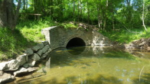
About: One of 74 locks located throughout the C&O Canal National Historical Park. Locks were used to raise and lower boats.
Tasks:
-Pick up and remove trash from site.
-Paint park features such as signs and picnic tables.
-Remove ash from fire ring.
-Survey site for hazards and note condition of the site.
-Clean signs.
62.09 Huckleberry Hill Hiker-Biker campsite
Location: Knoxville, MD 21758 Mile62.09
About: This hiker-biker campsite is located near where the Canal landing for the Potomac Refining Company’s landing once stood.
Tasks:
-Pick up and remove trash from site.
-Paint park features such as signs and picnic tables.
-Remove ash from fire ring.
-Survey site for hazards and note condition of the site.
-Clean signs.
64.9 Dargan Bend Boat Ramp
Location: Sharpsburg, MD 21782 Mile 64.9
About: Access for small boats on the Potomac River. Located upstream of Harpers Ferry.
Tasks:
-Pick up and remove trash from site.
-Paint park features such as signs and picnic tables.
-Remove ash from fire ring.
-Survey site for hazards and note condition of the site.
-Clean signs.
-Remove trash from boat ramp

Washington County
69.4 Antietam Aqueduct
Location: Sharpsburg, MD 21782 Mile 69.4
About: Carrying the C&O Canal over the Antietam is the Antietam Aqueduct, a three-span, 140-foot bridge that was completed in 1834. It was the fourth of 11 aqueducts built along the Canal. Heavily damaged during the Civil War, the aqueduct has been rebuilt and has otherwise withstood the forces of time and nature very well.
Tasks:
-Pick up and remove trash from site.
-Paint park features such as signs and picnic tables.
-Survey site for hazards and note condition of the site.
-Clean signs.
69.6 Antietam Campground GROUP SITE
Location: Sharpsburg, MD 21782. Mile 69.6
About: Just upstream about a quarter-mile from the mouth of Antietam Creek you’ll find the Antietam Drive-in Campground.
Tasks:
-Pick up and remove trash from site.
-Paint park features such as signs and picnic tables.
-Remove ash from fire ring.
-Survey site for hazards and note condition of the site.
-Clean signs.
75.4 Killiansburg Cave Hiker-Biker Campsite
Location: Sharpsburg, MD 21782 Mile 75.4
About: This is a hiker-biker campsite.
Tasks:
-Pick up and remove trash from site.
-Paint park features such as signs and picnic tables.
-Remove ash from fire ring.
-Survey site for hazards and note condition of the site.
-Clean signs.
76.67 Snyders Landing
Location: Snyders Landing, Sharpsburg, MD 21782
About: Another point of boat access to the Potomac River, Snyders Landing also includes parking on the berm side of the Canal. Originally named for the nearby town of Sharpsburg, it was later re-named after a local coal and grain establishment near the Canal here.
Tasks:
-Pick up and remove trash from site.
-Paint park features such as signs and picnic tables.
-Survey site for hazards and note condition of the site.
-Clean signs.
-Remove trash from boat ramp
79.07 Horseshoe Bend Hiker-Biker Campsite
Location: Sharpsburg, MD 21782 Mile 79.07
About: Where the Potomac River makes a huge U-shaped turn is the appropriately named Horseshoe Bend Campsite. Like other hiker/biker overnight stops
Tasks:
-Pick up and remove trash from site.
-Paint park features such as signs and picnic tables.
-Remove ash from fire ring.
-Survey site for hazards and note condition of the site.
-Clean signs.
80.9 Taylors Landing Boat Ramp
Location: Sharpsburg, MD 21782
About: Taylors Landing Boat Ramp has access to towpath as well.
Tasks:
-Pick up and remove trash from site.
-Paint park features such as signs and picnic tables.
-Remove ash from fire ring.
-Survey site for hazards and note condition of the site.
-Clean signs.
-Remove trash from boat ramp.
82.07 Big Woods Hiker-Biker Campsite
Location:
About: This hiker-biker campsite is not visible from the towpath. Bear Cave is half a mile upstream from this campsite.
Tasks:
-Pick up and remove trash from site.
-Paint park features such as signs and picnic tables.
-Remove ash from fire ring.
-Survey site for hazards and note condition of the site.
-Clean signs.
85.02 Dam 4 Area
Location: Dam 4 Rd, Maryland 21782 Mile 85
About: The seven dams on the Potomac River were originally built to divert water into the canal. Dam #4 provided water for 22 miles of the canal, from Milepost 84.6 downstream to Milepost 62.3, just above Harpers Ferry. The water was regulated at the guard lock at Dam #4 to maintain a consistent level of water traveling at two miles per hour down the canal prism.
Tasks:
-Pick up and remove trash from site.
-Paint park features such as signs and picnic tables.
-Survey site for hazards and note condition of the site.
-Clean signs.
90.9 Opequon Junction Hiker-Biker campsite
Location:
About: Looking across the Potomac from this campground, you’ll see the mouth of its namesake creek. Historically, Opequon Creek played an important role in pre-1800 America.
Tasks:
-Pick up and remove trash from site.
-Paint park features such as signs and picnic tables.
-Remove ash from fire ring.
-Survey site for hazards and note condition of the site.
-Clean signs.
95.2 Cumberland Valley Hiker-Biker campsite
Location: Williamsport, MD 21795 Mile 95.2
About: The first campsite south of Williamsport on the Canal, Cumberland Valley Campsite is named after the nearby railroad of the same name. The Cumberland Valley Railroad was built to connect Harrisburg, PA with Chambersburg—another Pennsylvania town near the Maryland border
Tasks:
-Pick up and remove trash from site.
-Paint park features such as signs and picnic tables.
-Remove ash from fire ring.
-Survey site for hazards and note condition of the site.
-Clean signs.
101.3 Jordan Junction Hiker-Biker Campsite
Location: Williamsport, MD 21795 Mile 101.3
About: This is the closest campsite to Williamsport.
Tasks:
-Pick up and remove trash from site.
-Paint park features such as signs and picnic tables.
-Remove ash from fire ring.
-Survey site for hazards and note condition of the site.
-Clean signs.
Four Locks-Washington County
109.6 North Mountain Hiker-Biker campsite
Location: Clear Spring, MD 21722 Mile 109.6
About: The name of this campsite comes from the high ridge across the Potomac River. Many people here also know it as Fairview Mountain.
Tasks:
-Pick up and remove trash from site.
-Paint park features such as signs and picnic tables.
-Remove ash from fire ring.
-Survey site for hazards and note condition of the site.
-Clean signs.
110.02 McCoys Ferry Campground GROUP SITE
Location:
About: This is a drive-in campground.
Tasks:
Pick up and remove trash from site.
-Paint park features such as signs and picnic tables.
-Remove ash from fire ring.
-Survey site for hazards and note condition of the site.
-Clean signs.
Washington county
110.02 McCoys Ferry Day Use/Boat Ramp Area
Location: Clear Spring, MD 21722 Mile 110.02
About: Fords and ferries were once located all along the 184.5 miles of the C&O Canal, providing places to cross the Potomac River. McCoys Ferry was one of those crossing sites.
Tasks:
-Pick up and remove trash from site.
-Paint park features such as signs and picnic tables.
-Remove ash from fire ring.
-Survey site for hazards and note condition of the site.
-Clean signs.
-Remove trash from boat ramp
116.04 Licking Creek Hiker-Biker Campsite
Location: Big Pool, MD 21711 Mile 116.04
About: This is a Hiker-Biker campsite near Licking Creek Aqueduct. Built between 1836 and 1838, the Licking Creek aqueduct is the first of six single-arch aqueducts on the line of the canal and the longest of the Canal’s aqueducts.
Tasks:
-Pick up and remove trash from site.
-Paint park features such as signs and picnic tables.
-Remove ash from fire ring.
-Survey site for hazards and note condition of the site.
-Clean signs.
120.39 Little Pool Hiker-Biker Campsite
Location: Hancock, MD 21750 120.39
About: Little Pool Campground provides great access to a number of Canal landmarks. To the south is Fort Frederick, Big Pool and Licking Creek Aqueduct.
Tasks:
-Pick up and remove trash from site.
-Paint park features such as signs and picnic tables.
-Remove ash from fire ring.
-Survey site for hazards and note condition of the site.
-Clean signs.
124.33 Little Tonoloway Day Use Area
Location: Hancock, MD 21750 Mile 124.33
About: Situated between the canal and Potomac River, this recreation area features picnic tables and a boat launch.
Tasks:
-Pick up and remove trash from site.
-Paint park features such as signs and picnic tables.
-Survey site for hazards and note condition of the site.
-Clean signs.
124.33 Little Tonoloway Boat Ramp
Location: Hancock, MD 21750 Mile 124.33
About:
Tasks:
-Pick up and remove trash from site.
-Paint park features such as signs and picnic tables.
-Survey site for hazards and note condition of the site.
-Clean signs.
-Remove trash from boat ramp
126.5 White Rock Campsite
Location: Hancock, MD 21750 Mile 126.5
Tasks:
-Pick up and remove trash from site.
-Paint park features such as signs and picnic tables.
-Remove ash from fire ring.
-Survey site for hazards and note condition of the site.
-Clean signs.
129.8 Leopards Mill Hiker-Biker
Location: Hancock, MD 21750 Mile 129.8
About: This riverside campsite was named after Jacob Leopard who operated a gristmill about a mile upstream.
Tasks:
-Pick up and remove trash from site.
-Paint park features such as signs and picnic tables.
-Remove ash from fire ring.
-Survey site for hazards and note condition of the site.
-Clean signs.
133.6 Cacapon Junction Hiker-Biker
Location: Hancock, MD 21750 Mile 133.6
Tasks:
-Pick up and remove trash from site.
-Paint park features such as signs and picnic tables.
-Remove ash from fire ring.
-Survey site for hazards and note condition of the site.
-Clean signs.
Allegany
139.02 Indigo Neck Hiker-Biker Campsite
Location: Little Orleans, MD 21766 Mile 139.02
About: Just a mile and a half downstream of the small town of Little Orleans, Indigo Neck campground is located on the southeastern tip of the expansive Green Ridge State Forest, with opportunities for hiking, off-road vehicles, fishing, boating and horseback riding.
Tasks:
-Pick up and remove trash from site.
-Paint park features such as signs and picnic tables.
-Remove ash from fire ring.
-Survey site for hazards and note condition of the site.
-Clean signs.
140.15 Fifteen Mile Creek Boat Ramp
Location: Little Orleans, MD 21766 Mile 140.15
Tasks:
-Pick up and remove trash from site.
-Paint park features such as signs and picnic tables.
-Remove ash from fire ring.
-Survey site for hazards and note condition of the site.
-Clean signs.
-Remove trash from boat ramp
140.15 Fifteen Mile Creek Campground/Aqueduct
Location: Little Orleans, MD 21766 Mile 140.15
About: Accessible by road. Just downstream from the mouth of Fifteen mile Creek is the town of Little Orleans, which served as a point of lumber transshipment on the Canal
Tasks:
-Pick up and remove trash from site.
-Paint park features such as signs and picnic tables.
-Remove ash from fire ring.
-Survey site for hazards and note condition of the site.
-Clean signs.
149.4 Stickpile Hill Hiker-Biker Campsite
Location: Big Pool, MD 21711 Mile 149.4
About: Stickpile Hill is another ridge that forces the Potomac River in its looping pattern along the southern edge of Green Ridge Forest State Forest.
Tasks:
-Pick up and remove trash from site.
-Paint park features such as signs and picnic tables.
-Remove ash from fire ring.
-Survey site for hazards and note condition of the site.
-Clean signs.
154.1 Sorrel Ridge Hiker-Biker Campsite
Location: Big Pool, MD 21711 Mile 154.1
Tasks:
-Pick up and remove trash from site.
-Paint park features such as signs and picnic tables.
-Remove ash from fire ring.
-Survey site for hazards and note condition of the site.
-Clean signs.
157.4 Purslane Run Hiker-Biker Campsite
Location: Oldtown, MD 21555 Mile 157.4
About: The Purslane Run Campsite is a half mile upstream from where the Western Maryland Railroad crosses back over the Potomac into Maryland. It is named for a stream another half mile up the Canal.
Tasks:
-Pick up and remove trash from site.
-Paint park features such as signs and picnic tables.
-Remove ash from fire ring.
-Survey site for hazards and note condition of the site.
-Clean signs.
162.1 Town Creek Aqueduct
Location: Oldtown, MD 21555 Mile 162.1
About: Town Creek Aqueduct is a single-span aqueduct. It is the tenth of eleven aqueducts on the Canal and, like many of the other eleven, is missing its upstream wall.
Tasks:
-Pick up and remove trash from site.
-Paint park features such as signs and picnic tables.
-Remove ash from fire ring.
-Survey site for hazards and note condition of the site.
-Clean signs.
164.8 Potomac Forks Campsite
Location: Oldtown, MD 21555 Mile 164.5
Tasks:
-Pick up and remove trash from site.
-Paint park features such as signs and picnic tables.
-Remove ash from fire ring.
-Survey site for hazards and note condition of the site.
-Clean signs.
169.17 Pigmans Ferry Campsite
Location: Oldtown, MD 21555 Mile 169.17
About: The name of this campsite is somewhat misleading. The site of the actual ferry is more than a mile and a half upstream and the campsite itself is not on the river—rather it is along the part of the Canal that veers inland away from the Potomac. The fenced off camping area borders a meadow.
Tasks:
-Pick up and remove trash from site.
-Paint park features such as signs and picnic tables.
-Remove ash from fire ring.
-Survey site for hazards and note condition of the site.
-Clean signs.
173.03 Spring Gap Campground
Location: Oldtown, MD 21555 Mile 173
Tasks:
-Pick up and remove trash from site.
-Paint park features such as signs and picnic tables.
-Remove ash from fire ring.
-Survey site for hazards and note condition of the site.
-Clean signs
175.4 Irons Mountain Hiker-Biker Campsite
Location: Cumberland, MD 21502 Mile 175.4
About: The Irons Mountain Ridge is the Canal’s last formidable ridge to navigate as it makes its way toward Cumberland. The campsite is upstream about a mile from the Narrows, the point where the River and the Canal squeeze by the ridge.
Tasks:
-Pick up and remove trash from site.
-Paint park features such as signs and picnic tables.
-Remove ash from fire ring.
-Survey site for hazards and note condition of the site.
-Clean signs
184 Cumberland Terminus
Location: Cumberland, MD 21501 Mile 184
About: Cumberland may be the end of the C&O Canal, but it was also once known as the “Gateway to the West.” The Potomac River cuts through the mountains in and around Cumberland, providing one of the easiest westward crossings.
Tasks:
-Pick up and remove trash from site.
-Paint park features such as signs and picnic tables.
-Remove ash from fire ring.
-Survey site for hazards and note condition of the site.
-Clean signs