
Celebrate your love for the C&O Canal by sharing your personal story about the Park. Each story will take a look at a person’s relationship with the C&O Canal. Whether an NPS ranger, a volunteer, or a visitor, everyone has a story to tell about the canal! If you want to share your story, fill out the form below, email it to us at [email protected] or post it on your social media feeds with the hashtag #MyCanalStory. We could use your story here on our website!
Canal Community Story: Joseph and Susan Adams Regalbuto
 Who would have expected to see Siberian Husky dog teams racing by, or wild turkey footprints in the snow, or cascading waterfalls frozen in ice? Winter walking on the C&O reveals many surprises.
With appreciation for William O Douglas’ vision of preserving the towpath and Thomas F. Hahn’s remarkable Towpath Guide to the C&O Canal, we ventured out to section walk the 184.5 mile length of the C&O Canal in both directions. The total mileage would have been 369 but we couldn’t resist adding a few more miles to explore side trips. Since we’re both retired and in our 70s it seemed like the perfect time to explore this historical gem.
Starting on the first day of winter in 2020, we averaged around 13 miles each day, 6 – 7 miles in each direction, returning to our car and driving home to Burke, Virginia, or to a hotel in Cumberland, Maryland, for the night. Two very special nights were spent in a lockhouse, where we set off on our walks from the lockhouse front door. The adventure lasted for 29 days of walking in an out-and-back pattern, usually walking twice a week, and visiting all 74 locks.
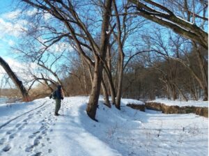 Although we were familiar with the lush greenery of the Canal towpath in three seasons, we had never seen the canal in the winter, without leaves blocking the views of Potomac River and the distant hills of West Virginia. Stone foundations hidden behind thick growth in other seasons now basked in the sun. The outdoor historical museum known as the C&O Canal was visible in all its winter glory.
Leaving behind the bustle of Georgetown, (Mile 0) we headed upriver on our journey through history, stopping at every lock and lockhouse to read the descriptions and marvel at the engineering.
The powerful roar of Great Falls (Mile 14) made it clear why six locks were needed within one mile – so canal boats could bypass the dangerous drop in elevation. Further upriver Edwards Ferry parking lot (Mile 30) was flooded with icy water; frozen puddles glistened on the towpath.
The Monocacy Aqueduct (Mile 42) is described as one of the most beautiful structures on the canal, with seven arches of pink quartz sandstone. Amazingly, this 1833 aqueduct is still standing after nearly 200 years of hurricanes and floods. We tried to visualize the aqueducts filled with water, allowing the canal to cross over rivers. Many of the C&O’s eleven aqueducts served as scenic spots for our lunch stops.
Near Brunswick (Mile 52) an old stone bridge over a culvert had collapsed and the towpath ended in a chasm. National Park Rangers constructed a temporary low wooden bridge, and we were relieved to find a way to continue our trek. The low bridge allowed us to view a culvert from below instead of walking over it. Hahn’s guidebook lists 241 C&O culverts, built so that streams could cross under the towpath. Some of the culverts are beautiful works of art, often missed by those treading on top of them.
Lots of caves in limestone cliffs appeared on this winter walk, no longer hiding behind deciduous trees. We explored several of the lower caves near Ferry Hill (Mile 72), walking upright for 30 feet into one of them. In another cave we saw hundreds of tiny stalactites forming on the walls and ceiling. The caves had the good earth smell of a newly tilled garden after a rain. High on the cliffs, cascading streams were now beautiful frozen waterfalls. This was a cold, windy day but because the river took two huge S turns, we never faced into the wind for long. A red fox with a bright white tail tip scampered across the trail in front of us, apparently oblivious to wind and cold.
We heard a new sound at Mile 84 – the thundering roar of water surging over a dam. As we rounded the bend, Dam 4 and the giant lake it formed came into view. The canal disappeared at this section, because canal boats could easily navigate the still water of this “slackwater” lake.
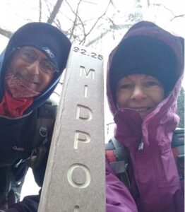
At McMahon’s Mill (Mile 88) the parking lot was so icy and that we used trekking poles and moved gingerly. The towpath itself offered safer walking, although with 5” of new snow, the progress was slow. Fresh tracks of deer, racoons, and smaller animals crossed our path. We were initially baffled by fairly large three-toed tracks that turned out to be wild turkey tracks. The towpath in this section came within yards of the Potomac River and steep cliffs came right down to the towpath. At times the river curved so sharply that we saw rope burns carved into the limestone cliffs, from the mules pulling the canal boats around the bend. At Milepost 92.25 we celebrated the snowy half-way point of our adventure.
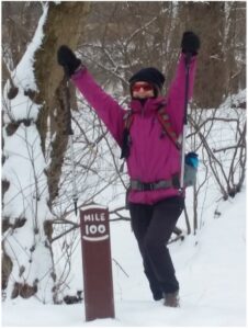
In late February of 2021 our walks were abruptly halted by two weeks of ice and snow. We optimistically drove to Williamsport (Mile 99) to continue on our route, but the trail was too icy for safe walking, even with trekking poles. The snow and ice were followed by a weekend of rain, and the Potomac flooded over its banks. On our next walk we watched entire trees hurtling downstream, and small “islands” of tangled bushes and chunks of land careening down the river. By the end of our day’s walk the river had risen to within a few feet of the towpath. We later learned that downriver, at mile 89, the towpath was impassable due to the high water.
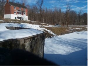
 We were impressed by the remarkably good condition of Williamsport’s Lock 44 and its lockhouse. We also examined the Conococheague Aqueduct, several weirs and a railroad lift bridge. The weirs are stone water chambers built beside locks to direct water away from the canal during high-water periods. The railroad lift bridge allows canal boats to pass beneath the movable tracks. This half-mile stretch includes more canal structures than anywhere else on the towpath. We tried to imagine towns like Williamsport at the height of the bustling canal activity as goods traveled downriver on the canal. In an interesting side note, Hahn adds that Williamsport was the capitol of the United States for 24 hours during the Revolutionary War!
In the Four Locks section (Mile 108) it was humbling to stand on the towpath looking upstream at Locks 47, 48, 49 and 50 and marvel at their construction and their endurance through all the years of floods. At the old mule barn, where mules lodged for the winter, we learned that mules were a cross between female horses (for their size and temperament) and male donkeys (for their strength and endurance – and their ears!) We also saw the tiny wait house at Lock 50 where lockkeepers could take refuge during storms.
 We stepped back in time to the late 1800s as we entered our lodging at Lockhouse 49. Squeaky timbered floors were covered with colorful braided rugs. Comfortable old rocking chairs and beautiful wooden tables also welcomed us. There was no running water for faucets, showers, or toilets, but we knew this in advance and we didn’t mind the walks to the outhouse. The lockhouse logbook was filled with impressions from both the young and old, from East Coast to West Coast. It also warned us of mice activity, so we gratefully returned all our food to the car! We would have gladly extended our stay in this peaceful place, but the towpath beckoned.
We trekked beside a very long lake aptly named Big Pool (Mile 112). It was at least 1½ miles long but it seemed longer with all the tiny flies that attached themselves to our pants, shirts, packs and shoes. As soon as we reached the end of the lake the flies miraculously disappeared. We met two other walkers on this section and their only comment was – “wow, some flies!”
At Mile 118 two beaver dams and two beaver lodges were clearly visible, with much evidence of saplings gnawed by beavers. Little beaver or muskrat trails led from the canal across the towpath to food sources in the field beyond.
At Hancock (Mile 124) we were greeted with a clear, sunny sky and a warm breeze. What a change from the snowy days when the temperature dropped into the 20s! During our walks we chose the most scenic spots we could find for lunch – beside an aqueduct, on the front step of a lockhouse, at the picnic table of a campground. On this day we sat on a log on a rise overlooking the Potomac River. We lingered over lunch in the sun, with expansive views of the West Virginia shoreline. Hancock is the most northern point of the canal and is only 1.7 miles from the Pennsylvania border. On our next day’s walk, we’ll be heading southwest. We now understand why the words “upriver” and “downriver” are used instead of “north” and “south” – because the Potomac River carves deep bends in all four compass directions.
To preserve six bat species living in Indigo Tunnel (Little Orleans, Mile 140), the Western Maryland Rail Trail detours onto the towpath for two miles. We walked up to look at the tunnel that was blasted through Germany Hill. Although we didn’t see any bats, we did see the bat gate that was erected at each end of the tunnel to allow bats to enter but to keep larger critters out.
The biggest challenge of the trip was the drive to the parking area of Bond’s Landing (Mile 150). After 30 minutes of negotiating rocks and water on a steep pothole-filled dirt road, we came to a rocky stream that was too deep to cross. Well out of cellphone range, we decided the safest route was to leave the car on Kasecamp Road and walk the remaining 1½ miles through streams and rocky hills. Apparently, we needed a four-wheel drive and not our little Toyota Prius. It took us three hours from our house to reach the towpath. To eliminate long driving distances for the last sections of the walk, we decided to spend the final three nights in Cumberland. The Fairfield Inn and Suites, located literally at the end of the towpath, became our new base camp.
What a fun section of strangely numbered locks – 62, 63 1/3, 64 2/3, and 66 – all within a half mile (Mile 154). The upriver end of the canal, with Locks 67-75, was built before this section; the numbers 62-66 were reserved for five locks in this area. However, to save money, Lock 65 was eliminated. The numbers saved for the five locks were then evenly divided between four locks, resulting in the fractions. Therefore, there are only 74 locks on the canal but the furthest upriver lock is named Lock 75!
We saw very few fellow walkers through the winter months, but we did meet three distance walkers pushing “Chariots,” much like Baby Joggers loaded with gear. They were walking across the country from Delaware to California on the American Discovery Trail. We later learned that they successfully reached their destination – the Pacific Ocean.
We were excited to walk through PawPaw Tunnel (Mile 155), one of the greatest engineering feats of the mid-1800s. It took fourteen years to complete the tunnel, drilling through almost ¾ miles of solid rock. The sound of water dripping, falling, and flowing; the sight of light at the end of the tunnel growing larger and larger; the smell of wet dirt and tiny little mushrooms on the walls – these were totally different sensory experiences for us. With our headlamps we searched in vain for bats hanging from the six million bricks that lined the tunnel.
Just for fun, we walked across the Oldtown toll bridge (Mile 166) to eat lunch sitting on a stone wall in Greenspring, West Virginia. This low wooden bridge, the shortest bridge crossing of the Potomac River, is one of the very few private toll bridges in the country. Charge for cars: $ 1.50. When we asked the woman in the toll booth if there was a charge for walkers, she replied, “Free as you go.”
The next day was filled with sights and smells: eight deer, three horses, dozens of cows – some with calves too young to leave their mother’s side – countless turtles, a rabbit, and lots of farm scents! We detoured to a little gated cemetery maintained by the Cumberland Historical Cemetery Organization. The Organization’s President, who was changing flags on the flagpole, proudly gave us a tour of the Pollack family gravesites.
A cacophony of sounds suddenly exploded from the trees and we searched for tiny birds hidden among the branches. Instead, the noise heralded the 17-year return of the cicadas. Croaking frogs and screeching Pileated Woodpeckers added their own sounds to the buzzing cicadas. The earth smell gave way to a vegetation smell and green buds appeared on the trees. Soon the expansive view of the Potomac River and the far shoreline will be hidden again behind foliage.
The view coming into Cumberland (Mile 184.5) was a memorable sight, with church steeples in the near distance and blue hills in the far distance. To commemorate the completion of our walk, we raised a toast of Paw Paw lemonade bottled in Cumberland, as we reminisced about our very special winter walk through history.