

Arguably, what makes the C&O Canal National Historical Park one of the most unique parks in the over 430 NPS system is its structure. The C&O Canal is a linear park, traveling across four Maryland counties for over 184.5 miles. The towpath is vital to the park’s identity, serving as the backbone for the recreational, cultural, and natural resources that all visitors come out to enjoy.
The towpath is continuous, meaning there are no breaks in the entire trail – at least, right now.
There have been moments in park history where there have been threats to towpath continuity. In 1972, Hurricane Agnes swept across the eastern United States, causing massive flooding along the canal. This storm caused significant damage. More than 200,000 trees had been ripped from the park, and 66 miles of towpath were damaged by the storm.
In 1996, there were two historic floods that took out a 2.7 mile section of the towpath near Big Slackwater, causing a five-mile detour for thru-hikers and bikers to the park. This “missing link” to towpath continuity remained in effect for nearly 15 years. In 2012, the National Park Service completed the Big Slackwater Restoration, after spending over $19 million to fix the breach. The project was funded through the American Recovery and Reinvestment Act and the Maryland Department of Transportation’s Transportation Enhancement Program, and donations from the C&O Canal Association, Washington County, Town of Williamsport and the Hagerstown and Washington County Convention and Visitors Bureau.
Recently, in spring of 2025, there was a major flood event that destroyed a section of the towpath in Oldtown. The National Park Service worked diligently to repair the hole, successfully completing the project in seven months. The restoration was made possible by a $10,000 donation to the C&O Canal Trust from Mountain Maryland Trails.
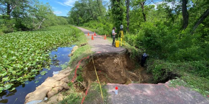
Towpath breach in Oldtown before repairs.
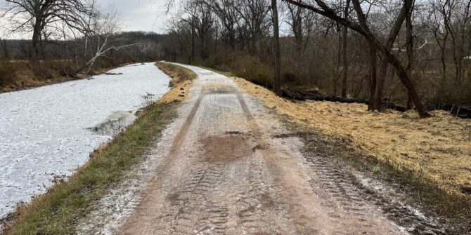
Rehabilitated towpath after repairs.
As the nonprofit partner to the park, the Trust works in tandem with NPS to secure funding to support towpath continuity and rehabilitation. In 2016, an engineering study was conducted with the assistance of the Allegheny Trail Alliance (ATA). They found that the entire towpath urgently needed rehabilitation. The National Park Service put forth a plan to remediate the trail in sections with priority on areas where conditions of the trail have been most affected by potholes, drainage issues, roots, etc.
Since 2018, when the project first began, the Trust, in partnership with the National Park Service and the State of Maryland’s Transportation Alternatives Program (TAP), has rehabilitated over 120 miles of the towpath. What does restoration look like? Rocks, roots, and other debris are removed before the trail is then degraded to facilitated water runoff. A crushed stone dust is then applied to the towpath’s surface, making it less likely to erode and rut.
As the towpath is the largest historical structure and the backbone of the park, its maintenance is critical to the park’s preservation. Together, we can continue to protect the park and its towpath. Through the Trust’s Towpath Forever fund, visitors to the park can help support the rehabilitation and continuity of the towpath.

Photos by Simon Barber, Francis Grant-Suttie, NPS, Chris Hanessian